This article was originally published in the “A new cartography” edition of the pan-African gazette 'Chimurenga'.
The territory occupied by the Wahhabi terrorist group currently calling itself Islamic State is broadcast all over news networks and websites, a disparate spread across Syria, Iraq and now also Lebanon, the visual representation of which is not wholly without a reminder for viewers of a stain, a pool of blood.
In professionally produced videos, masked men reject the borders that were imposed on them and announce a new caliphate, the map of which they then release on Twitter. This caliphate, they announce, will stretch from Iraq to Spain through all of North Africa.
While they attempt to reach their goal, which will require the summary and brutal execution of absolutely every single person who in any way disagrees with them, newscasters provide us with new maps confirming their progress, or the lack thereof – a slightly different shape to the pool of blood each day, a Rorschach blot you can interpret depending on your mood.
This notion of having to update maps daily, of fearing for loved ones after seeing shapes morph on a screen to encompass new areas where family members live, takes me back almost two decades to the fall of 1996 and the kitchen table in the small suburban apartment outside Paris where we lived. On this table, an old map was spread out, a few trinkets and ashtrays weighing down its four corners, food having to be eaten elsewhere.
The map – drawn before 1930, when maps regularly depicted Kurdistan, a name that has been in use since the 12th century – showed in impressively clear detail the cities and even villages scattered around the mountainous area between Iran, Iraq, Turkey and Syria. Chess pieces were positioned over cities, mirroring that day’s reality.
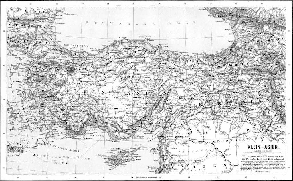
Earlier that summer, one of the two major political parties in Iraqi Kurdistan had entered into an ill-advised alliance with the Iraqi dictator Saddam Hussein and was waging war against the other political party. Cities exchanged hands daily; friends and family members became refugees, their houses looted, torched.
Every day I would leave the mundane hormonal trivialities of high school life, with its unrealistic crushes and the illusory importance of endless exams, at the door, while reality would rearrange itself in front of my eyes in the shape of cheap wooden chess pieces at home. We would worry about loved ones, make a few phone calls that resulted in the repositioning of a black rook or a white pawn, and then the next day I would return to school where no maps hung that even showed that Kurdistan existed at all.
To discuss the map at home and its chess pieces with friends was akin to talking about the topography in a fantasy novel none of them had read.
As a child this often became problematic. Before we moved to France, I was one of many foreign children in an immigrant-heavy neighbourhood in Sweden in the 1980s.
One day, as an exercise, my teacher made me point out to the rest of the class where I was from. Except, of course, on the classroom map, as on most maps, where I am from does not exist. Being Kurdish, as a consequence of treaties held in small picturesque European towns after World War I, I belong nowhere.
So I stood, embarrassed, in front of a classroom of restless children, my finger hovering above the Middle East. Any country my finger could land on would have been a lie.
My teacher sent me back to my seat, visibly annoyed. She would have a word with my parents, she said. Children should know where they are from.
During my teens, I did my best to find out where I was from, which wasn’t easy as I came from a family in exile: I sought a 15th-century book of grammar on the Kurdish language by an Italian monk named Garzoni, and tried to read Karl May’s adventure tale, Durchs Wilde Kurdistan, in German, although I do not speak the language.
After finding a passage in Emile Zola’s Au Bonheur des Dames that mentioned, in passing, Kurdish rugs as the most exclusive rugs of their time, I kept repeating this factoid to anyone who cared to listen. Zola said so, after all, and therefore it had to be true.
These were acts of excavation, of finding and preserving small nuggets of information about my identity. And, of course, there were maps. Gorgeous 19th-century maps including the word Kurdistan where, only a few decades later, when the concept of the nation-state was becoming the norm in the Middle East, the word would disappear entirely.
Collecting these maps became a hobby of mine, a way of constructing an alternative history, and in an antique shop in the Kurdish city of Slemani I found a particularly beautiful specimen, drawn by the Ottomans at the beginning of the 20th century, the word Kurdistan writ in large italics across the Zagros mountains.
Between 1992, when the no-fly zone was created by the United Nations, and 2003, when the first nonmilitary flights began to land in Kurdish cities, the only way into and out of the region was an arduous and often illegal process requiring travel through Iran or Turkey, crossing of no-man’s-lands and the occasional bribe of border patrol officers.
The way back out through these countries was especially onerous, as you had to explain to the guards where you had just come from without being allowed to say the word “Kurdistan” (which, in Turkey at the time, was not deemed to exist and so identifying it as such would land you into all kinds of trouble).
I was usually adept at being just evasive enough to be let through without selling out my heritage by pretending to be something that I am not. (Others were not so lucky – a woman once claimed to have been held at the border for days. The reason? Her actual name was Kurdistan.)
On the visit during which I bought the map, Turkish border officers demanded to see what was inside the plastic tube hanging from my shoulder. The map was removed carefully, as though I had handed them a quiver filled with poisonous arrows. The border officer shook his head. “This is not correct,” he said of the map and confiscated it.
This may sound outrageous until you realise that, to this very day, under pressure from the Turkish government, Facebook’s “abuse standard violations” lists “maps of Kurdistan” alongside “depiction of the mutilation of people or animals” and “depiction of sexual assault and rape in any form”, which are banned.
After the United States invasion of Iraq in 2003, it became easier to be an Iraqi Kurd. First and foremost, it was possible to refer to oneself that way: Kurds were allowed to be part of the Iraqi government for the first time, the first democratically elected president of Iraq was even a Kurd, and so it rankled less to utter those words.
Kurdish nationalism, after all, is a product of repression – had Kurds been given basic human rights and the ability to freely assert their ethnic identity, there could have been a far more harmonious existence within the countries in which we were scattered.
It was suddenly possible to fly there, although at first the destinations remained controversial, at least in the Arab world. For years, Dubai airport refused to name the cities in Kurdistan and simply presented a series of question marks on their monitors, as though one had found a secret level in a video game, requiring hushed verbal confirmations that this was indeed the flight to Slemani.
But soon the names began to appear on departure screens even there, and not long after the tiny electronic maps showing the jerky flight trajectory began writing out the Kurdish cities that the cartoon planes were flying over. We existed. People began to know who Kurds were: no longer did the sentence “I’m Kurdish” require a 10-minute history lesson and the drawing of crude maps on napkins.
Foreign companies even began referring to “the Kurdish region” to single out the prosperous and safe Kurdish area from the rest of Iraq, as there was money to be made in making such a distinction.
Indeed, when the US on August 8 2014 began providing aid to thousands of displaced Yazidi and Christians, and air support in the fight against the Islamic State, it wasn’t because of the humanitarian disaster that had claimed so many lives for several months (and, in the case of Syria, years); rather it was not only that the Islamic State forces were approaching the Kurdish city of Erbil, the oldest continuously inhabited city in the world, but also, more importantly, the site of several international companies and diplomatic consulates. Money, it turned out, was all the Kurds needed to be recognised.
But identity forged in exile is not easily reconciled with reality: the Kurdish diaspora, one of the world’s largest, did not prepare we children of migrants for what it meant to return “home”.
Though the world began recognising us as Kurds, many Kurds did not. In the eyes of many, I am Swedish, as that is where I grew up. My language, frozen in time at the moment my grandfather left Iraq decades ago, is seen as overly formal, almost archaic.
When I was happy to see Kurdistan shown on a BBC infographic explaining the various Iraqi regions, my friends were unimpressed: of course, this is Kurdistan, they said. What else would it be? They didn’t understand why someone else needed to acknowledge a place for that place to exist.
Although intellectually this made sense, it was hard to let go of the decade-long habit of collecting totems related to Kurdistan to prove to others and myself that it existed.
Then, one day, I saw a young nephew of mine colouring in Kurdistan in green crayon on a world map that did not include it, and all my books and maps became irrelevant. I needn’t have scoured the earth for ancient maps after all. I could just have drawn them myself.
This is by no means the final word. The commissioning and research is always ongoing and we welcome contributions, thoughts and reflections. The aim, as always, remains, to write our world differently.
This article was originally published in the “A new cartography” edition of the pan-African gazette Chimurenga, which asks: what if maps were made by Africans for their own use, to understand and make visible their own realities or imaginations? In collaboration with Kwani?, they invited writers and artists to produce this in words and images. Visit chimurengachronic.co.za for more information