Water flows through the concrete pipe and across a gravel road before going under the R24. (Trevor Brough)
The Trans-Caledon Tunnel Authority (TCTA) has urged people living along the Tweelopies Spruit on Gauteng’s West Rand to stop using water in the interlinked streams, rivers and dams following the spillage of toxic acid mine water.
Last month, the TCTA said the area adjacent to the treatment site of the Western Basin acid mine drainage (AMD) plant had been “significantly affected” by the increased rainfall, which had caused the untreated water to decant into the environment, causing degradation.
Acid mine drainage is harmful to people, plants and animals because it is acidic and carries atoms that emit radiation and salts in hazardous concentrations.
The TCTA operates three AMD plants in three mining basins, which are designed to treat the polluted water from old underground gold mines on the Witwatersrand, on behalf of the department of water and sanitation. These are the Western Basin (Randfontein), Eastern Basin (Springs) and Central Basin (Germiston). The Western Basin plant is operated jointly with Sibanye-Stillwater.
Johannes Mavuso, the TCTA’s executive manager for project management and implementation, said that the plant had been operating without any major interruptions for the past year, averaging 34 million litres a day and the shaft level was maintained well below the decant (or spillage) point.
“But the excessive rain in the past few weeks has caused a spike in the water level in the Western Basin, thus leading to overflow at 18 Winze [a shallow point near Sibanye Treatment facility]. The overflow from 18 Winze combines with runoff water caused by torrential rains in the area and the water discharged from the Western Basin AMD plant, before entering the Tweelopies Spruit,” Mavuso said.
TCTA spokesperson Wanda Mkutshulwa said this week that heavy rain in November and December meant the water was still overflowing at 18 Winze.
“The average treated acid mine water for the month of December was 32.54 megalitres per day, which implies that the AMD plant is operating within the design parameters of between 30 to 35 megalitres per day,” Mkutshulwa said.
She said it was difficult to quantify the volumes because some streams are flowing on the side and are not contained in the collection pond while other streams from the mine feed to the collection pond. For this reason “the pH levels at the collection pond are not a complete reflection of the decanting water pH levels at 18 Winze”.
The TCTA is implementing a temporary plan to neutralise the acidic mine water with caustic soda at the collection pond to mitigate the environmental risks, Mkutshulwa said.
The aim of this intervention is to raise the pH level to between seven and nine.
“The effects to the rivers and the water users have been carefully managed, as illustrated in the mitigating measures taken, and TCTA is in continuous communication with key stakeholders in the area.”
Mkutshulwa said the pH of the 17 Winze and the 18 Winze overflow averaged 5.27 in December and is now at 6.20. “We have increased the dosage of caustic soda and are monitoring progress. The plant is currently operating without interruptions.”
Acid mine drainage does not only have a low pH and high acidity, said Mariette Liefferink, the chief executive of the Federation for a Sustainable Environment. “Several other elements or determinants are also present in the water, mostly metals. Many of these metals are present in toxic concentrations in the water. Radioactive metals also occur in the water.”
That the pH of the decanting water is measuring at about six is the “only positive thing” of the overflow, she said. “The problem is the metals — the manganese, the cobalt, copper, the arsenic, the uranium …. The water contains these metals in toxic concentrations so that now continues to flow again into the Tweelopies Spruit … which flows into the Crocodile West.”
Liefferink warned that if raw acid mine drainage decants without intervention, it may pose risks to the Cradle of Humankind World Heritage Site, human and aquatic life, fauna, the environment and surface and groundwater quality.
Acid mine drainage first decanted on the West Rand in 2002 and continued for a decade until 2012, when the government implemented its short-term treatment intervention.
She said the department should have put in place precautionary measures. “The failure to implement the long-term solution [to fully treat acid mine drainage], the fact that there was no environmental impact assessment conducted to determine the risks and hazards, the fact that they have now heightened the environmental critical level [ECL] …
“The department said it was too conservative — there was too much gap between the surface and pumping; they said they must keep pumping 30 to 40 million litres a day not to compromise the environmental critical level, but then [claimed] the ECL was established too conservatively. They can heighten it, but now this has happened, because there was no sufficient capacity for extreme weather events such as La Niña … and extreme rainfall. The precautionary principle should have been applied.”
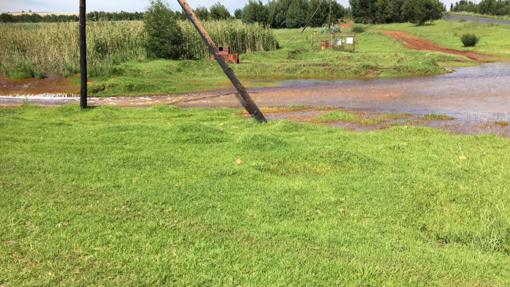 Spillage: Higher than usual rainfall in Gauteng has resulted in excess water flowing from the Western Basin, damaging roads and bridges.
(Trevor Brough)
Spillage: Higher than usual rainfall in Gauteng has resulted in excess water flowing from the Western Basin, damaging roads and bridges.
(Trevor Brough)
Trevor Brough, a director of the nonprofit Cradle of Humankind World Heritage Site Association, said: “The main concerns are what the real impact on the overall environment is and what that impact is on residents.
“Unfortunately, they are attempting to keep the pH neutral by adding, from what I understand, caustic soda as an emergency measure.”
He said the Cradle area is underpinned by dolomite, which is dissolved by water over time.
“The speed of the decay of the dolomite is dependent on the pH of the water as well as what other chemicals are present in the water,” Brough said.
“The band of dolomite stretches from Carletonville, through Tarlton, the Cradle of Humankind to Centurion. The geologists tell us that 23% of Gauteng is underpinned by dolomite.”
He said this band has had numerous sinkholes over the years and poses some degree of danger to the residents, adding that he knew of two sinkholes in December last year. “One was a smallish one on the boundary of a property. The second on 13 December was a larger one on the Sterkfontein Caves road, which runs parallel to the Blaaubank Spruit. Surface water is generally the biggest cause [of sinkholes], but is aggravated by happens underground, which nobody knows.”
A further concern for residents in the Cradle area is groundwater contamination. “Most of the residents, including myself, are dependent on boreholes for drinking water as well as any agricultural activities,” Brough said. “From the geology and hydrology reports of the area there is a reasonable amount of the surface water that enters the groundwater system, which we then extract via boreholes and use. Over time, the groundwater will be contaminated to some extent.”
Brough had seen a Council for Scientific and Industrial Research report from 2013 analysing water in the Sterfontein caves. “In the report … there were indications of pollution from the Blaaubank Spruit appearing in the cave water. The Blaaubank Spruit is quite close to the caves and is downstream from the Tweelopies Spruit, so the various chemicals and metals in the acid mine drainage outflow will be noticed in our groundwater.”
Environmental expert Garfield Krige said the effect of the excess water flowing from the Western Basin mine void does not end at the Krugersdorp Game Reserve opposite the decant site.
“The greatest impact is at the bridge where Malmani Road passes over the Rietspruit. The road is the only access to Sterkfontein Country Estates, a community of 167 smallholdings, of which I am a resident and I also operate my business from the premises.
“The excess flow in the stream has had … financial implications to these residents because the bridge has washed away and we now have to repair it at our own cost.”
Responding to Liefferink, Wisane Mavasa, spokesperson for the department of water and sanitation, said it agreed that it is ultimately responsible for work being done by the TCTA “because the TCTA is an entity of DWS and the TCTA is doing this work on behalf of DWS”.
“Any strategy aimed at completely eliminating acid mine drainage would be extremely expensive and complex and would be a high burden on the fiscus. As an interim measure, DWS appointed TCTA and Sibanye-Stillwater as implementing agents to pump water out of the Western Basin and neutralise it.”
The DWS, together with the Water Research Commission, and key roleplayers within the mine water sector, had investigated alternative long-term possibilities to address the current acid mine drainage issues faced within the Witwatersrand and a report would be released in due course.
“The reason that no EIA was conducted for the short-term intervention was due to the urgent nature of the situation at that time. If an EIA process had been followed, the negative impact would have been much greater,” Mavasa said.
“The department acknowledges the current challenges faced due to climate change … It, however, should be highlighted that the decant experienced in the Western Basin is not only due to extreme rainfall events, but it does play the biggest role. The cessation of [liquidated] Mintails operations in the Western Basin has had a significant impact on the water level within the basin.”
Mintails abstracted a large volume of water daily, in the order of 10 million litres a day compared to the average 30 million litres a day abstracted and treated by the treatment plant, to use within its processes. “The effect thereof should be taken into consideration. Other factors such as illegal mining activity within the West Rand are also a contributing factor in the rising water level,” she said, adding that illegal mining leads to numerous ingress points, which exacerbates the situation in the Western Basin.
[/membership]