We had reached the top of Namahadi Pass as the sun was setting. The top of the pass is above 3 000m, about two kilometres from the better-known chain ladders which bring you to the top of the Amphitheatre in this section of the Drakensberg.
There is a long-abandoned police station and three or four half-buildings made from large rocks shaped into giant bricks. The light is fading. We choose one to set up camp, and collect water from a nearby stream.

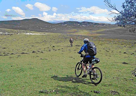
Bridle path from Namahadi pass
Some wood for a fire would be nice and I ask Mike to slip down the mountain to fetch some. We have measured the treeline earlier at 1 800m, meaning that this foray would mean losing 1 200m of altitude just to get firewood. Since it has taken us the whole day to get to the top of the mountain, no one is up for this.
Our host the previous night, Ephraim Hlwatswayo, had warned us to be off the mountain by 4.30pm as after this dagga smugglers use the pass. The smugglers presumably double as livestock rustlers on the return trip as this is a widespread activity in the area.
Hlwatswayo tells us that his grandfather’s farm at the foot of the Namahadi pass has had all its livestock stolen, most recently 22 sheep.
We — Mike Roy, Lynn Morris and I — have come to check out Namahadi as a possible way into Lesotho on a north-south mountain bike traverse. We should have been joined by two others, but Nic Dawes is nursing a shoulder injury and Tim James, an SAA pilot, is waylaid in London, waiting for the volcanic ash from Iceland to subside.
We began our trip at the Catfish and Catterpillar, a lodge at the top of the Oliviershoek pass, just south of the Sterkfontein dam. The plan was to move along the escarpment and then drop into the outskirts of the township of Phuthatdijaba in the eastern Free State, before climbing Namahadi pass and following a track to the A1, one of the main roads through Lesotho. We aimed to do all of this, about 75km in all, on the first day.
An SMS to Lynn from a friend, Ollie Schwankhart, who was at Afriski in Lesotho, not far from where we were heading, told us that it had snowed the previous night and was very cold.
We left the Catfish at sunrise, following a jeep track for a few kilometres, before hiking our bikes up past sandstone cliffs to the escarpment with fine views of the Sterkfontein dam. The wind was howling. At one point it started raining, hurling stinging, sleet-like drops at us.
Tim, kicking his heels in London, SMSed to say that snow was forecast for Letseng that night and the temperature would be minus one, but that the weather would then clear over the following few days.
The going was very slow. We managed to ride our bikes for only about three kilometres of 20km, taking seven hours to complete the first section.
While the area is relatively populated on both the Free State and KZN side of the mountain, our route is remote. We did not see a single person, just a few horses and two dogs.
Based on how long it takes to get up Lehana’s pass on the Freedom Trail, we had agreed that we’d have to start the Namahadi pass at midday to be at the top by 3pm to give us time to cycle the 30-odd kilometres from the top to the Letseng diamond mine, where Mike had arranged accommodation.
It was clear, though, that we’d not make a midday departure. In fact, we have relied on the directions of locals when we get to Phuthatdijhaba rather than our maps, and this adds somewhat to our distance travelled — 47km for the day. We are not going to make the top of Namahadi, never mind Letseng, so we need a place to stay.
I know from what I have read on the web that there is a lodge at the Fika Patso dam, which is also where the Namahadi pass starts, so we head for it. The shadows are lengthening and night is falling as we get within sight of the lodge. A security guard tells us that the place has been closed since 2004 when the owner died. It is too late to turn back so we cycle on for a closer look.
The next house has a sign outside, 4Cousins. A car wash operates from the site. The entrepreneur, the aforementioned Ephraim, sees that we are not in need of washing our bikes, but accommodation. He will put us up in his grandfather’s house at R100 a head. We agree, also arranging for an emissary to head off to the nearest spaza shop to buy us three litres of coke, six eggs and half a loaf of white bread.
We ask Ephraim if there are still any Bushmen in the area. He tells us about Bushmen paintings on his grandfather’s farm about a kilometre up the road, even drawing copies of some of the paintings. We ask again, stressing we are interested in Bushmen.
He thinks awhile and then offers that there was a Khoisan man living in the area until a couple of years ago, but he does not know what became of him.
The Hlatswayos make us very comfortable, giving up their beds. We eat our hydrated camping food, roast lamb and veg with mashed potatoes, which is pretty good, wash and go to bed. Departure is at least an hour too late at 7.30am thanks to an alarm which was set by mistake for 5.15pm rather than 5.15am.
Towards the Metsimatsi dam. (Mike Roy)
By now we are excellent terms with the family and are invited to Ephraim and sister’s upcoming 21st birthday party, which sounds like it will be quite a bash. Ephraim has borrowed a bike to show us the route, but as we climb out of the valley we find that somehow we have lost him or he has lost us and we don’t see him again.
We can see the top of the Namahadi pass as we begin our trek. It is 16km to the top. I had not heard of Namahadi before beginning to plan this trip and consider the various options of how to get into Lesotho using a mountain bike.
But Namahadi has such a ring to it that it soon came to represent to me a great chief, a warrior whose reputation had rung up and down these valleys. I was more than a little disappointed, then, when I asked the Hlatswayos who Namahadi was. They looked at me puzzled.
“Namahadi,” I said, “the person who the pass is named after.”
“No,” I was told. “The pass is named after the river. It is the Namahadi river.”
Yes, I insisted, but isn’t the river then named after a great leader?
“No, Namahadi means a pile of meat.”
I remember that meat is nyama in isiZulu, so seSotho and isiZulu share similar names for meat.
The pass was always going to be a big ask.
Lehana’s pass on the Freedom has quickly gained legendary status because it is a vertical kilometre which has to be climbed to an altitude of 2 700m over a distance of about five kilometres. Namahadi is a vertical ascent of 1 300m over 10km to 3 066m.
Our bikes weigh about 18kg and backpacks 10kg, a combined 28kg when the bike has to be portaged, which is for much of the way, the path being steep, rocky and uneven. The day is ending as we get to the top.
My plan had been to not sleep in this area because thefts from hikers — including slitting the sides of tents — are not infrequent based on what you read of these incidents on the web. But we are out of options and so quickly settle down for the night in the former police post.
We lay out our sleeping kit, have more re-hydrated food — lamb with couscous — and turn in.
Temperatures fall to below zero during the night. In the morning we get Lynn’s cooker on the boil again to make instant oats and coffee.
We have the easy task of following the Khubule river for 30km towards the A1. We have heard that 4×4’s have come along this track so we reckon that it will be mostly rideable. It is not.
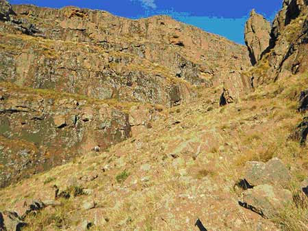
Save the odd tyre tracks of enduro bikes which somehow manage to get up the very rocky Namahadi pass, there is little to no sign of any traffic, even by foot. The track is in fact an old, little-used bridle trail. Age has made it rutted and difficult to walk, never mind ride.
But you would not want to rush this section anyway. We have the place to ourselves. There are a few grass and rock shelters built by shepherds, but no people. This could be because they have already left these summer pastures for lower, warmer ground.
There are mountains as far as we can see. When we stop to eat, which we do infrequently, we sit in awe of the splendour around us.
Great drama has played out here in recent times. Some of the last Bushmen lived here during the mid-1800’s, mounting livestock raids against the settlers in then Natal.
These Bushmen, as we see in Pat Vinnicomb’s People of the Eland, were a Stone Age people who operated at industrial strength. They moved on horseback. In cases they were armed.
Their modus operandi was to steal livestock in Natal under cover of bad weather. They then herded their contraband up precipitous mountain passes, not unlike Namahadi, to the highlands of Lesotho where they traded the animals with the Basutho, some of whom acted as their allies.
They used their craft of ages to get the posse off their tracks, back-tracking and re-crossing their own tracks to throw their pursuers off the scent. When the posse drew near, they resorted to rainmaking and other subterfuges to keep the quarry at bay.
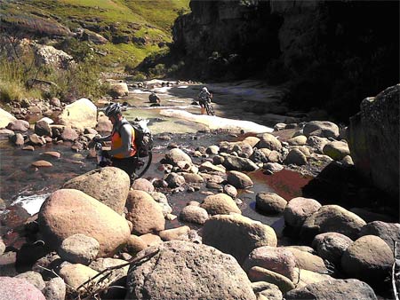
Walking bikes up the Namahadi river
In one famous incident recounted by Vinnicomb, the pursuers were drawing close to their prey who were up ahead moving through a kloof. A Bushman broke the skyline, producing an eland horn which he blasted, bringing down a torrent of rain.
Vinnicomb manages to mostly keep her disdain for the fact that the Bushmen way of life was wiped out to herself, but she does speak of the surviving Bushmen bands of this time as a “broken people”. She also decries the fact that while the Bushmen lifestyle is no more, the cattle rustling which was the cause of the colonials taking armed action, continues to this day along the borders of Lesotho.
This is all true, but there was an additional factor in the case of the Bushmen, as Vinnicomb notes. As the posse would close in, the thieves would cut the tendons of the stolen animals or stab them with assegaais, creating mayhem and ensuring that no one benefited from the stolen contraband.
It was all or nothing, while livestock rustling as still practised in the area we are traversing, has a more gentlemanly nature about it. Whoever gets to keep the animals, wins.
I even remember a story, and I can’t remember the location, where a herd of cattle was stolen. When the owners went to retrieve their animals they found that a calf had been born while the animals were in the charge of the thieves. They told the owners that they could take the cattle, but not the calf as its birth location made it their property.
Steve Black, who ran the Thin Air, runs a pony trekking outfit in the Underberg area. When he returned home after the event he found that horses had been stolen. He immediately set out to get his animals back, eventually using Google Earth to help trace them.
He told me about the incident, [one of numerous] that year, on the phone. It was mid-winter and snow was forecast that night. “There’ll be more thefts tonight,” said Black, knowing that the bad weather would provide cover to the rustlers as it has in these parts for yonks.
We head towards the Pass of the Guns, named after the four-year War of the Guns between the Basutho and the Cape Colony after Basutoland, as it was then known, was annexed, by the Colony in 1880. After four years “ownership” reverted to the British Empire with Basutoland as a protectorate.
Our ride has turned into a 30km hike. A hike this long can take all day and this one does. The sun is again going down and we are short of our destination. We can expect the temperatures to plummet and so must find a place to stay. A cave will do nicely.
About 100m above us is a cliff face with a large black hole indicating a cave. We heave our bikes on to our backs for the last time today and climb up to the rock face. As I get near I see that it is not a cave after all, but a dark marking where falling water has coloured the rock. No matter, we are out of time and will sleep here with the cliff at least giving us wind protection from one side.
We are at 3 300m, not too shy of the 3 482m of Thaba Ntletyana, the highest peak in Africa south of Kilimanjaro. There is not even time to get water, but we boil up what we have to make instant soup and noodles.
Lynn and I both have bivy bags which act as a mini tent. We put on all our clothes, including waterproof outer wear and get into our sleeping and bivy bags. We’re warm.
Mike has a sleeping bag which is somewhat too small, an all-weather blanket and body bag which he uses as a ground sheet. He freezes, in the morning telling us that he had considered pushing on to Letseng during the night. We tell him that we would not have let him go.
In the morning we push our bikes to above the cliff, where we slept, to the plains above. This is the top of the Pass of the Guns or Khaleng-la-Lithunya in local parlance. We spy the A1 below us with a car or two on it. After two days without seeing people, we are again connected to civilisation.
We cycle along the A1 and up the Tlaeeng Pass, the highest in Southern Africa at 3 275m, to what we had planned as our first night’s destination, the Letseng diamond mine, arriving on day four.
Letseng was operated by De Beers between 1997 and 1982. Operations reopened in 2004 with the mine now being 70% owned by Gem Diamonds and 30% by the Lesotho government.
Its website says at 3 100m it is one of the coldest places in Africa and is well known for producing large gem diamonds, claiming the highest dollar value per carat of any kimberlite diamond mine.
But diamonds are far from our minds as we head for the tuck shop for coffee, Coke, chocolate and double toasted sarmies with egg, bacon, cheese, onion and ham.
We have chosen to include Letseng on our route because Mark Mcleod, who runs the Thin Air with his wife, Nicki, has told us of a track which runs along the top of the escarpment from Letseng, down to the Senqu River. This 70km downhill seems too good to miss, but Lynn is looking shattered. We will find out in two days’ time that she is brewing bronchitis and pleurisy. We will stick to the main road.
Nearing the top of Namahadi pass. (Mike Roy)
We take the A1 south. This section of the road used to be tar but is now mostly gravel. We drop down a vast, splendid valley, losing altitude and gaining warmth as we head for the Senqu river and the lowlands where most of the Basutho live.
There are few cars on the road. Almost without exception they are government vehicles. Private car ownership seems very low indeed.
We cycle about 70km on this day, day four, but are about 10km shy of our target, Molumong Lodge, as the light begins to fail. I strike up a conversation with a woman at Sekokong who has a home above the Senqu and she offers to accommodate us.
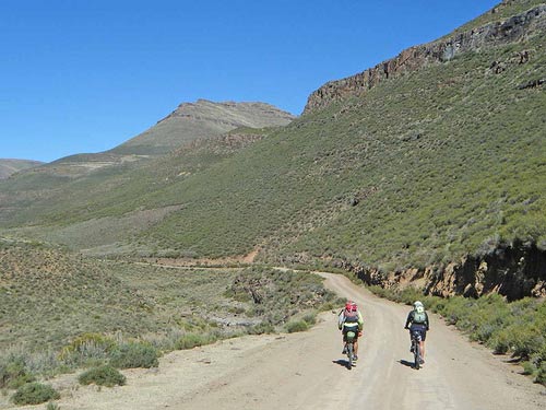
Heading for Black Mountain and Sani Pass. (Mike Roy)
Alida Mohomotsi is a teacher, her husband a mineworker, who will soon depart for a year’s stint as an underground supervisor at the Simmer & Jack gold mine at Klerksdorp.
Alida opens her home to us, arranges three beds/mattresses in a room and brings a supply of hot water so that we can wash. Her brother, Jacob, a taxi driver, brings bread, eggs and Coke from the town of Mokhotlong about 10km away.
In the morning we cycle down to the Senqu, which is pronounced with a large click, telling us that the word has its origins in an ancient click language. We take photographs on the bridge over the river which has a massive presence in the country, having carved out an immense valley for itself.
We don’t follow the Senqu, though, but rather a tributary, the Sehonghong, which heads towards Sani Pass. Along the way we climb over 25km to the top of Black Mountain (Kotisephola) pass, at 3 240m the true top of the Sani Pass. The 360° views are spectacular.
The pace is slow as Lynn has woken with a head cold and is struggling with the altitude. We drop down about 400m from Black Mountain and head towards the Sani Top chalets at the border post with South Africa. It boasts the highest permanent pub in South Africa, roaring fires, non-stop hot drinks and accommodation above the clouds.
We arrive as the day ends, the temperature falling in minutes to minus three. In a moment Lynn is hypothermic and has to thaw out in front of the fire. In the morning she will do the sensible thing and get a lift to Underberg where she is checked out by a doctor.
Mike and I come down the famous Sani Pass. We have achieved less than half of what we set out to do, but have been above 3 000m on four passes. We have slept out on two nights and have found new appetite for bikepacking.
We have enjoyed the warmth and friendliness of the Basutho and are keen to take in more of this rarefied, high-altitude life. But next time we will do more riding and less pushing and carrying.
On the way back to Jo’burg we stop in the Berg just short of where we had started at Oliviershoek Pass, at Sungubala camp, to find out if there is a way up the mountain at this point which might be a less arduous route than the one we had followed.
Cindi Jonker, Sungubala’s proprietor, has a keen interest in tourism in the area, particularly activity pursuits such as hiking and biking.
She said that Namahadi pass is a no-go from a tourism point of view. Even the conservation authorities do not go up this pass unless they are armed. While the tourist literature says that the only crime on the top of the mountain is theft, Jonker said she had in recent days heard of two incidents in the past two months where hikers had been robbed at gunpoint.
In a pamphlet, Oscar the Otter says … Take care in the mountains, which is published by Ezemvelo KZN Wildlife and I picked up after the trip, has this advice: ” Theft from overnight hikers has occasionally been reported and this mostly occurs on the top of the escarpment, especially the Amphitheatre. Should you become aware of a security risk in the late afternoon, have an early supper and arrange equipment to easily set up camp.
“After dark, move without lights to a new camping site and sleep as close as possible to each other and arrange a night watch.”
It continues: “If your camp is raided by bandits at night, use a whistle to warn other members of your group, grab your jacket and abandon camp. Take the rest of your kit only if you have sufficient time.
“Sleep with your clothes and boots on and keep your kit packed into your bag at night. Do not resist with force as you are at a definite disadvantage at this time. Every person in the group should note the exact location of each night’s campsite, in order that anyone can provide this information to a rescue team in an emergency.”
It ends with this sentence printed in red: “Have a planned escape route from your campsite and an identified meeting point in case your group becomes split up.”
I asked Cally Henderson, editor of the Mountain Club of SA’s journal, what advice MCSA gives to its members. She said that there had been a history of incidents, including a famous event a few years back at Mike’s Pass in the Cathedral Peak area where the conservation authorities had a full shoot-out with a 90-strong group of smugglers.
Cally said that the MCSA put out reports on an on-going basis of trouble spots. This would lead to hikers avoiding these areas, giving the thieves slimmer pickings. But the insecure security situation on the top of the Berg did not, by and large, keep hikers away.